

Disclaimer:
The authors are solely responsible for the content of this report. Material included herein does not represent the opinion of the European Community, and the European Community is not responsible for any use that might be made of it.
Back to overview reports
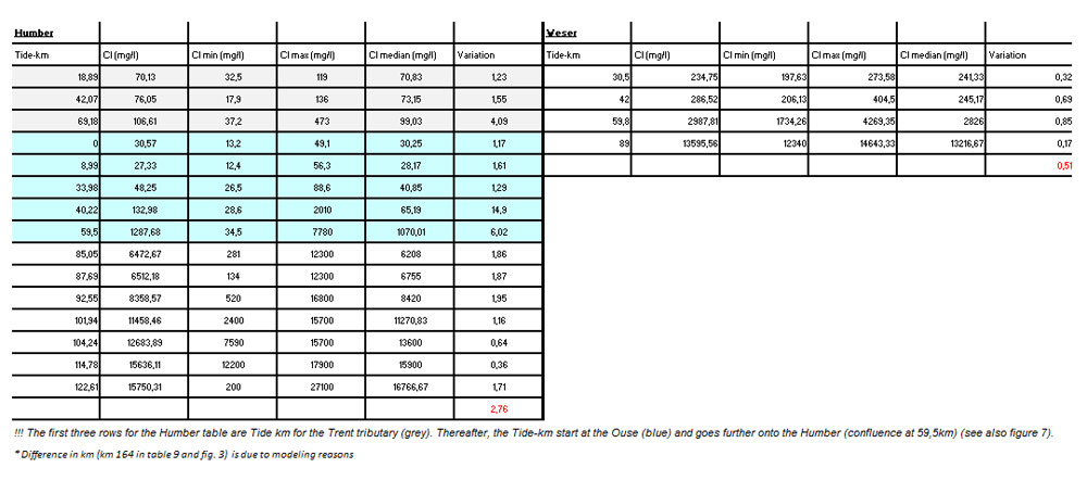
The Venice approach is a physiotope approach, in which different zones are assumed based on salinity range. Salinity is known as a conservative tracer, and as having the most influence on ecology. This approach has proven to be useful in the Harbasins project. Although, salinity is very variable in time and space, a six yearly average for the period of investigation (2004-2009) can be assumed as a good basis estimation for the distribution of different ecological entities. Herefore, annual and seasonal calculations of averages, median, minimum and maximum values for 2004-2009, per measuring station were performed (see table 8, 9, 10, 11, seasonal values here not included) with the data received from all estuaries.
Six yearly median values of chlorinity were eventually used as a guidance for zonation, because of the non-normal distribution of chlorinity data in the Schelde and Humber. This was due to different sampling methods in Schelde & Humber and also shows in the large variation of the Schelde & Humber compared to the Elbe & Weser (see table 8, 9, 10, 11). The variation is calculated as :
(Clmax- Clmin)/ Clmean
Existing zonation schemes of each estuary, described above, are fitted as good as possible in this Venice approach, so previous calculations as volume and area,… can be reused.
The freshwater zone, which can not be further divided according to salinity, is splitted into zones based on existing zonation schemes and expert judgement when ought to be useful.
From all the considerations mentioned above, the following zonation scheme can be suggested:
In the Schelde the freshwaterzone is splitted into 2 zones based on residence time (FW 1 short residence time ~ < 5 days, FW2 long residence time ~ > 5 days; cf. Harbasins report – Physiotope system). In the Elbe three zones can be considered. This is based on morphology and use (harbour) (see earlier – table 2, p. 6). The Weser only dessignates two freshwaterzones based on the degree of urbanisation with the first freshwaterzone as the urban area from Hemelingen sluice up till Farge, and the second freshwaterzone as the rural area from Farge up to Brake. In the Humber no further splitting up for the freshwaterzone was suggested. The four maps based on the agreed Tide zonation are presented beneath:
Back to top
Zonation of the TIDE estuaries
Table of content
Authors:
by Lindsay Geerts, Kirsten Wolfstein, Sander Jacobs, Stefan van Damme & Wouter Vandenbruwaene
by Lindsay Geerts, Kirsten Wolfstein, Sander Jacobs, Stefan van Damme & Wouter Vandenbruwaene
4. 3. Zonation according to Venice for al TIDE estuaries
From the detailed description of zonation schemes per estuary, as outlisted here before, it is obvious that different approaches exist and merely trying to compare these different approaches is not very evident. Therefore, it was decided in Rouen (June 2011), that the Venice approach in general should be used (Table 7).The Venice approach is a physiotope approach, in which different zones are assumed based on salinity range. Salinity is known as a conservative tracer, and as having the most influence on ecology. This approach has proven to be useful in the Harbasins project. Although, salinity is very variable in time and space, a six yearly average for the period of investigation (2004-2009) can be assumed as a good basis estimation for the distribution of different ecological entities. Herefore, annual and seasonal calculations of averages, median, minimum and maximum values for 2004-2009, per measuring station were performed (see table 8, 9, 10, 11, seasonal values here not included) with the data received from all estuaries.

Six yearly median values of chlorinity were eventually used as a guidance for zonation, because of the non-normal distribution of chlorinity data in the Schelde and Humber. This was due to different sampling methods in Schelde & Humber and also shows in the large variation of the Schelde & Humber compared to the Elbe & Weser (see table 8, 9, 10, 11). The variation is calculated as :
(Clmax- Clmin)/ Clmean
Existing zonation schemes of each estuary, described above, are fitted as good as possible in this Venice approach, so previous calculations as volume and area,… can be reused.
The freshwater zone, which can not be further divided according to salinity, is splitted into zones based on existing zonation schemes and expert judgement when ought to be useful.

From all the considerations mentioned above, the following zonation scheme can be suggested:

In the Schelde the freshwaterzone is splitted into 2 zones based on residence time (FW 1 short residence time ~ < 5 days, FW2 long residence time ~ > 5 days; cf. Harbasins report – Physiotope system). In the Elbe three zones can be considered. This is based on morphology and use (harbour) (see earlier – table 2, p. 6). The Weser only dessignates two freshwaterzones based on the degree of urbanisation with the first freshwaterzone as the urban area from Hemelingen sluice up till Farge, and the second freshwaterzone as the rural area from Farge up to Brake. In the Humber no further splitting up for the freshwaterzone was suggested. The four maps based on the agreed Tide zonation are presented beneath:


Important to know
Reports / Measures / Tools
| Tool: | Zonation of the TIDE estuaries (Recommendation) |
|---|