
Disclaimer:
The authors are solely responsible for the content of this report. Material included herein does not represent the opinion of the European Community, and the European Community is not responsible for any use that might be made of it.
Back to overview reports
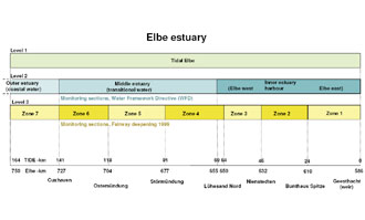
The zonation of the Elbe estuary consists of three levels (fig. 3).
Level 1 consists of the entire tidal Elbe. The most upward boundary is the sluice near the city of Geesthacht where the tidal action ends. At the seaward end, close to the city of Cuxhaven, the estuary passes into the coastal area of the North Sea.
Level 2 is based on a zonation of outer, middle and inner estuary, partly adjusted to the WFD, in which the outer estuary corresponds to the WFD compartment ´coastal water´ (polyhaline), the middle estuary corresponds to the WFD zone ´transitional water´ (oligo - polyhaline), and the inner estuary merges the three WFD compartments ´Elbe west, harbor, Elbe east´ and covers the freshwater part of the estuary. Within the WFD this zonation (Elbe west, harbour, Elbe east) is mainly chosen because the harbour area differs so much from the other zones concerning the morphological characteristics, e.g. concerning water depth. Elbe east consists of lower water depth, whereas the harbour and Elbe west have much deeper water depth because they are harbour area and contain the fairway respectively.
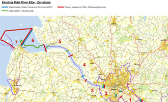
Level 3 consists of 7 zones based on the monitoring sections for the fairway deepening in 1999 (fig. 4). The border of zone 3 does not match exactly with the border of the inner estuary, a difference of about 5 km occurs. Zones 4 - 6 more or less correspond to the middle estuary. Zone 7 starts at the same border as the outer estuary. Due to modeling reasons its seaward border is set at km 164 (corresponding to Elbe km 750).
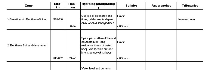
A detailed description of the underlying parameters for the zonation is given in table 2 and 3. The basic characteristics of the Elbe zones at level 3 are hydrological and morphological characteristics, the average salinity distribution according to the Venice system and the influence of tributaries and anabranches.
Please note that in tabel 3 the borders of the zones of level 2 (WFD) in most cases not match with the borders of level 3 zones (see fig. 3 and annex). Volume and surface area are calculated for areas situated lower than mean tidal mean water and mean tidal low water respectively.
Back to top
Zonation of the TIDE estuaries
Table of content
Authors:
by Lindsay Geerts, Kirsten Wolfstein, Sander Jacobs, Stefan van Damme & Wouter Vandenbruwaene
by Lindsay Geerts, Kirsten Wolfstein, Sander Jacobs, Stefan van Damme & Wouter Vandenbruwaene
3b. 2b. Zonation per estuary - Elbe
In the Elbe estuary three (administrative) zonation schemes exist at the moment:- Water Framework Directive (WFD),
- Natura 2000,
- Zonation based on the monitoring program of the fairway deepening in 1999.
The zonation of the Elbe estuary consists of three levels (fig. 3).
Level 1 consists of the entire tidal Elbe. The most upward boundary is the sluice near the city of Geesthacht where the tidal action ends. At the seaward end, close to the city of Cuxhaven, the estuary passes into the coastal area of the North Sea.
Level 2 is based on a zonation of outer, middle and inner estuary, partly adjusted to the WFD, in which the outer estuary corresponds to the WFD compartment ´coastal water´ (polyhaline), the middle estuary corresponds to the WFD zone ´transitional water´ (oligo - polyhaline), and the inner estuary merges the three WFD compartments ´Elbe west, harbor, Elbe east´ and covers the freshwater part of the estuary. Within the WFD this zonation (Elbe west, harbour, Elbe east) is mainly chosen because the harbour area differs so much from the other zones concerning the morphological characteristics, e.g. concerning water depth. Elbe east consists of lower water depth, whereas the harbour and Elbe west have much deeper water depth because they are harbour area and contain the fairway respectively.
Level 3 consists of 7 zones based on the monitoring sections for the fairway deepening in 1999 (fig. 4). The border of zone 3 does not match exactly with the border of the inner estuary, a difference of about 5 km occurs. Zones 4 - 6 more or less correspond to the middle estuary. Zone 7 starts at the same border as the outer estuary. Due to modeling reasons its seaward border is set at km 164 (corresponding to Elbe km 750).
A detailed description of the underlying parameters for the zonation is given in table 2 and 3. The basic characteristics of the Elbe zones at level 3 are hydrological and morphological characteristics, the average salinity distribution according to the Venice system and the influence of tributaries and anabranches.
Please note that in tabel 3 the borders of the zones of level 2 (WFD) in most cases not match with the borders of level 3 zones (see fig. 3 and annex). Volume and surface area are calculated for areas situated lower than mean tidal mean water and mean tidal low water respectively.
Important to know
Reports / Measures / Tools
| Tool: | Zonation of the TIDE estuaries (Recommendation) |
|---|


