

Disclaimer:
The authors are solely responsible for the content of this report. Material included herein does not represent the opinion of the European Community, and the European Community is not responsible for any use that might be made of it.
Back to overview reports
Level 1 includes the entire estuary from downstream of the weir Hemelingen (TIDE-km 0) where the tidal influence is stopped to the seaward border of the outer Weser estuary (TIDE-km 134, see level 2). The border of the outer Weser corresponds with the seaward border of the euhaline zone mentioned under level 4 (see also figure 5).
Level 2 is based on a common zonation scheme drawing a distinction between the lower Weser estuary (TIDE-km 0-69) and the outer Weser estuary (TIDE-km 69-134).
Level 3 includes the zonation schemes deduced according to WFD and BHD. Both comprise three zones. The zone borders according to the both directives differ slightly from each other and from the other zonation levels.
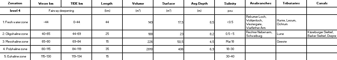
Level 4 consists of five different salinity zones defined according to the Venice system. The salinity zone borders correspond with level 1 and level 2. Figure 5 shows the geographical position of the five salinity zones along the Weser estuary. This zonation scheme was inter alia used for the recent fairway deepening.
A detailed description of the underlying parameters for the zonation is given in table 4 and 5. The basic characteristics of the Weser zones at level 4 are hydrological and morphological characteristics, the average salinity distribution according to the Venice system and the influence of tributaries and anabranches.
Back to top
Zonation of the TIDE estuaries
Table of content
Authors:
by Lindsay Geerts, Kirsten Wolfstein, Sander Jacobs, Stefan van Damme & Wouter Vandenbruwaene
by Lindsay Geerts, Kirsten Wolfstein, Sander Jacobs, Stefan van Damme & Wouter Vandenbruwaene
3c. 2c. Zonation per estuary - Weser
There are five common (administrative) zonation schemes for the Weser estuary. The zonation of the Weser estuary includes four different levels; the zonation schemes according to WFD and BHD are both assigned to level 3 (fig. 5).Level 1 includes the entire estuary from downstream of the weir Hemelingen (TIDE-km 0) where the tidal influence is stopped to the seaward border of the outer Weser estuary (TIDE-km 134, see level 2). The border of the outer Weser corresponds with the seaward border of the euhaline zone mentioned under level 4 (see also figure 5).
Level 2 is based on a common zonation scheme drawing a distinction between the lower Weser estuary (TIDE-km 0-69) and the outer Weser estuary (TIDE-km 69-134).
Level 3 includes the zonation schemes deduced according to WFD and BHD. Both comprise three zones. The zone borders according to the both directives differ slightly from each other and from the other zonation levels.
Level 4 consists of five different salinity zones defined according to the Venice system. The salinity zone borders correspond with level 1 and level 2. Figure 5 shows the geographical position of the five salinity zones along the Weser estuary. This zonation scheme was inter alia used for the recent fairway deepening.

A detailed description of the underlying parameters for the zonation is given in table 4 and 5. The basic characteristics of the Weser zones at level 4 are hydrological and morphological characteristics, the average salinity distribution according to the Venice system and the influence of tributaries and anabranches.

Important to know
Reports / Measures / Tools
| Tool: | Zonation of the TIDE estuaries (Recommendation) |
|---|