
Disclaimer:
The authors are solely responsible for the content of this report. Material included herein does not represent the opinion of the European Community, and the European Community is not responsible for any use that might be made of it.
Back to overview reports
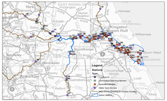
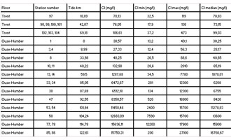
Nevertheless for the TIDE focus, a zonation scheme is adopted, as a starting point for an objective interestuarine comparison. This was based upon calculations for salinity (see further, table 10). A map (fig. 7) and table (table 6) give an overview of this new zonation approach.
Back to top
Zonation of the TIDE estuaries
Table of content
Authors:
by Lindsay Geerts, Kirsten Wolfstein, Sander Jacobs, Stefan van Damme & Wouter Vandenbruwaene
by Lindsay Geerts, Kirsten Wolfstein, Sander Jacobs, Stefan van Damme & Wouter Vandenbruwaene
3d. 2d. Zonation per estuary - Humber
The zonation of the Humber differs from that of the other three estuaries. A nested approach was not applied. However, besides the shown zonation (fig. 6), zonation schemes have been developed to meet new management needs, or schemes have been suggested e.g. under HARBASINS. It should be noted that Natural England do not very often divide the estuary up, considering instead, that it should be treated as a single system. However, when they do, they use the Environment Agency CHaMP zonations e.g. for saltmarsh conservation objectives and condition assessment the estuary is split into inner, middle and outer based on the fact that the saltmarshes are different in these sections of the estuary. The zones used are inner to the bridge, middle to Grimsby/ Hawkins Point and then the Outer estuary.Nevertheless for the TIDE focus, a zonation scheme is adopted, as a starting point for an objective interestuarine comparison. This was based upon calculations for salinity (see further, table 10). A map (fig. 7) and table (table 6) give an overview of this new zonation approach.
Important to know
Reports / Measures / Tools
| Tool: | Zonation of the TIDE estuaries (Recommendation) |
|---|


