
Disclaimer:
The authors are solely responsible for the content of this report. Material included herein does not represent the opinion of the European Community, and the European Community is not responsible for any use that might be made of it.
Back to overview reports
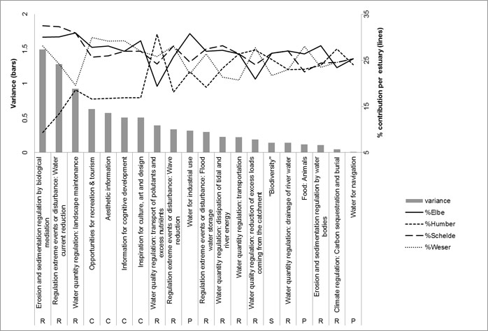
The main inter-estuarine variations are caused by lower importance scoring of all cultural and some regulating services in the Humber, and lower scoring of ‘landscape maintenance’ in the Weser. In these analysis, ‘unknown’ scores are added as zero, instead of leaving them out of the average. This assumes very low demand when demand is unknown by the regional working group. This occurred for very few services.
The lower scoring of three regulating services (biological mediation of sedimentation and erosion, water current reduction and landscape maintenance) in the Humber could reflect the exceptional features of this estuary compared to the others: extremely high turbidities, almost ‘fluid mud’ conditions on tidal flats and lack of rigid subtidal structures and marsh habitats (ref “Interestuarine comparison: hydro- geomorphology”) .
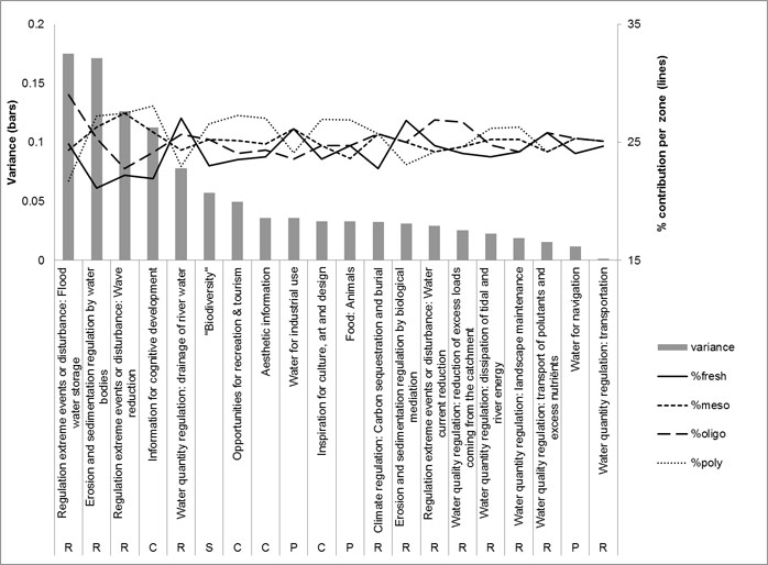
Salinity zones were defined in four zones: freshwater zone, oligohaline, mesohaline and polyhaline zone. This allowed to obtain a similar, comparable zonation over all four TIDE estuaries. However, this also reduced the detail of estuaries with more elaborate zonation schemes of the report “zonation of the TIDE estuaries” (eg the Elbe contains three freshwater zones and the Scheldt 10 zones), which were averaged within the four comparable zones. In some single cases the merge of the freshwater zones can lead to results which differ from the result obtained by the expert group; this will be indicated at the particular cases.
Variations between salinity zones are generally very low. Only about four services exert small variations in demand along the salinity gradient. In these cases, the fresh and oligohaline zones separate from the meso- and polyhaline zones. Three of these higher demands can be linked to the specific features of the upper reaches of estuaries: higher flood risk, vulnerability for high turbidities induced by tidal pumping and wave erosion of habitats and infrastructures in confined upper reaches.
Back to top
How can public acceptance for management actions be increased?
How can the Ecosystem Services Approach be used to support management decisions?
How do TIDE estuaries deal with management problems?
How does habitat management affect the supply of ecosystem services?
How does the societal demand for ecosystem services vary along the estuary gradient?
What are the key areas of conflicts or synergies in TIDE estuaries?
What is important in establishing a zonation for estuaries?
Which aspects do I have to take into account in order to make a measure a success?
Which measures are suitable to achieve specific ecological targets?
Which measures are suitable to provide ecosystem services and benefits?
Which synergistic effects and conflicts can be expected by planning and implementing a certain measure?
“Working with nature”: What are the opportunities for sediment management in estuaries?
Ecosystem Service Assessment of TIDE Estuaries
Table of content
- 1. Summary
- 2. Introduction
- 2a. Ecosystem Services
- 2b. Ecosystem Services in Estuaries
- 2c. Key questions and general approach
- 3. TIDE ES - Assessment methodology
- 3a. From ES longlist to key ecosystem services
- 3b. Expert survey reliability: theory
- 3c. TIDE Survey methodology & reliability
- 4. Results: demand survey for ecosystem services in four EU estuaries
- 4a. Which are the key ecosystem services?
- 4b. Spatial aspects of ES demand
- 4c. Temporal aspects of ES demand
- 5. Supply of ecosystem services in four EU estuaries
- 5a. ES supply by habitats
- 5b. Determining conservation objectives with ES
- 5c. ES supply maps
- 5d. Functional ES supply
- 5e. Inter- and intra-estuarine ES supply patterns
- 5f. Habitat contributions to ES supply
- 6. Historical image of ES value
- 7. Trade-off risk assessment
- 8. Assessment of estuarine management measures
- 9. Ecosystem Services in TIDE: Conclusions
- 9a. Key question answers
- 9b. Future challenges
- 9c. Conclusion
- 10. Acknowledgements
- 11. References
Authors:
by Sander Jacobs, Wouter Vandenbruwaene, Dirk Vrebos, Olivier Beauchard, Annelies Boerema, Kirsten Wolfstein, Tom Maris, Sonja Saathoff and Patrick Meire
by Sander Jacobs, Wouter Vandenbruwaene, Dirk Vrebos, Olivier Beauchard, Annelies Boerema, Kirsten Wolfstein, Tom Maris, Sonja Saathoff and Patrick Meire
4b. Spatial aspects of ES demand
The inter-estuarine or inter-zone variance of scores is plotted, together with the % contribution of the respective zone/estuary. This allows to evaluate which scores caused the higher variances.The main inter-estuarine variations are caused by lower importance scoring of all cultural and some regulating services in the Humber, and lower scoring of ‘landscape maintenance’ in the Weser. In these analysis, ‘unknown’ scores are added as zero, instead of leaving them out of the average. This assumes very low demand when demand is unknown by the regional working group. This occurred for very few services.
The lower scoring of three regulating services (biological mediation of sedimentation and erosion, water current reduction and landscape maintenance) in the Humber could reflect the exceptional features of this estuary compared to the others: extremely high turbidities, almost ‘fluid mud’ conditions on tidal flats and lack of rigid subtidal structures and marsh habitats (ref “Interestuarine comparison: hydro- geomorphology”) .
Salinity zones were defined in four zones: freshwater zone, oligohaline, mesohaline and polyhaline zone. This allowed to obtain a similar, comparable zonation over all four TIDE estuaries. However, this also reduced the detail of estuaries with more elaborate zonation schemes of the report “zonation of the TIDE estuaries” (eg the Elbe contains three freshwater zones and the Scheldt 10 zones), which were averaged within the four comparable zones. In some single cases the merge of the freshwater zones can lead to results which differ from the result obtained by the expert group; this will be indicated at the particular cases.
Variations between salinity zones are generally very low. Only about four services exert small variations in demand along the salinity gradient. In these cases, the fresh and oligohaline zones separate from the meso- and polyhaline zones. Three of these higher demands can be linked to the specific features of the upper reaches of estuaries: higher flood risk, vulnerability for high turbidities induced by tidal pumping and wave erosion of habitats and infrastructures in confined upper reaches.
Important to know
Reports / Measures / Tools
| Tool: | Ecosystem service trade-off risk tool (Decision support) |
|---|---|
| Tool: | Mapping tool for estuarine ecosystem service supply (Decision support) |
| Tool: | Survey tool for screening of estuarine ES demand and supply (Methodology) |
| Tool: | Defining Conservation goals based on Ecosystem Services in the Scheldt (Examples of good practice) |
Management issues
How can ecosystem services of estuaries be valued?How can public acceptance for management actions be increased?
How can the Ecosystem Services Approach be used to support management decisions?
How do TIDE estuaries deal with management problems?
How does habitat management affect the supply of ecosystem services?
How does the societal demand for ecosystem services vary along the estuary gradient?
What are the key areas of conflicts or synergies in TIDE estuaries?
What is important in establishing a zonation for estuaries?
Which aspects do I have to take into account in order to make a measure a success?
Which measures are suitable to achieve specific ecological targets?
Which measures are suitable to provide ecosystem services and benefits?
Which synergistic effects and conflicts can be expected by planning and implementing a certain measure?
“Working with nature”: What are the opportunities for sediment management in estuaries?

