

Disclaimer:
The authors are solely responsible for the content of this report. Material included herein does not represent the opinion of the European Community, and the European Community is not responsible for any use that might be made of it.
Back to overview reports
For the Elbe, two high scores were identified: flood protection from flood bank (dyke/gabion/wall);and vessel movement.
For the Scheldt, five high scoring uses/concerns were identified: recreational access on water; recreational access along the banks and intertidal zone; commercial access; flood protection from flood bank (dyke/gabion/wall);and channel stabilisation for navigation.
For the Weser high uses/concerns were identified as being: recreational access along the banks and intertidal zone; flood protection from flood bank (dyke/gabion/wall); channel stabilisation for navigation;and residential housing adjacent to the estuary.
Based on the above, the limnetic zone featured three high scoring uses/issues in the Humber, with a total score for the zone of 40. For the Elbe, two high scoring uses/issues were identified, with a total score for that region of the estuary of 40, the same as the Humber. The Scheldt featured five high scoring uses/issues with again an overall score of 41 for the estuary zone being broadly comparable to those of the Humber and Elbe. However, whilst four high scoring uses/issues were identified, the overall score for the zone was considerably higher than the other estuaries (51).
Only the use/issue of flood protection from flood bank (dyke/gabion/wall) was common across all estuaries as being afforded the highest score. However, when all scores across the four TIDE estuaries are combined, then the following uses/issues were rated as a moderate/high combination (e.g. a score in excess of 8 from a maximum of 12), ranked from highest score downwards.
Limnetic zone high uses/issues categories:
For the Elbe, six high scoring uses/issues were identified: protected areas for conservation adjacent to the system; protected areas for conservation in the subtidal; protected areas for conservation in the intertidal; recreational access on water; flood protection from flood bank (dyke/gabion/wall);and vessel movement.
On the Scheldt, 11 high scoring uses/issues were noted: protected areas for conservation adjacent to the system; protected areas for conservation in the subtidal; protected areas for conservation in the intertidal; recreational access on water; recreational access along the banks and intertidal zone; commercial access; flood defence set-back; flood protection from flood bank (dyke/gabion/wall); channel stabilisation for navigation; vessel movement;and residential housing adjacent to the estuary.
The Weser group rated five high scoring uses/issues from the oligohaline zone: protected areas for conservation in the subtidal; protected areas for conservation in the intertidal; flood protection from flood bank (dyke/gabion/wall); channel stabilisation for navigation; and agricultural run-off.
Based on the above, the oligohaline zone featured three high scoring uses/issues in the Humber, with a total score for the zone of 40. For the Elbe, six high scoring uses/issues were identified, but with a total score of 38. The Scheldt featured 11 high scoring uses/issues unsurprisingly giving a total score for the zone of 55, the highest individual zone score for any estuary and zone from the analysis. The Weser featured five high scoring uses/issues with a total usage score of 45.
As with the limnetic zone, only the use/issue of flood protection from flood bank (dyke/gabion/wall) was common across all estuaries as being afforded the highest score. However, when all scores across the four TIDE estuaries are combined, then the following uses/issues were rated as a moderate/high combination (e.g. a score in excess of 8 from a maximum of 12), ranked from highest score downwards.
Oligohaline zone high uses/issues categories:
Further details of the uses/issues analysis for the oligohaline zone are given below in Figure 7.
For the Elbe, four high scoring uses/issues were identified: protected areas for conservation in the subtidal; protected areas for conservation in the intertidal; flood protection from flood bank (dyke/gabion/wall);and vessel movement.
On the Scheldt, 11 high scoring uses/issues were again noted, in this zone being: protected areas for conservation in the subtidal; protected areas for conservation in the intertidal; recreational access along the banks and intertidal zone; commercial access; flood protection from flood bank (dyke/gabion/wall); channel stabilisation for navigation; capital dredging; maintenance dredging for navigation; vessel movement; aggregate extraction;and agricultural run-off.
The Weser group rated 10 high scoring uses/issues: protected areas for conservation in the subtidal; protected areas for conservation in the intertidal; flood protection from flood bank (dyke/gabion/wall); channel stabilisation for navigation; capital dredging; maintenance dredging for navigation; vessel movement; port land claim; port related activity adjacent to the estuary;and port activity on the intertidal and subtidal.
Based on the above, the mesohaline zone featured eight high scoring uses/issues in the Humber, with a total score for the zone of 52. For the Elbe, four high scoring uses/issues were identified, with a total score of 37. The Scheldt again featured 11 high scoring uses/issues giving a total score for the zone of 52, and the Weser featured 10 high scoring uses/issues with a total usage score of 51.
In the mesohaline zone, the categories of: protected areas for conservation in the subtidal; protected areas for conservation in the intertidal; flood protection from flood bank (dyke/gabion/wall); and vessel movement were afforded the highest score across all estuaries. Combining all estuary scores for the zone then identifies the following uses/issues as being rated as a moderate/high combination (e.g. a score in excess of 8 from a maximum of 12), ranked from highest score downwards.
Mesohaline zone high uses/issues categories:
Water abstraction for agricultural use and water abstraction for residential use were identified as not being present as a use/issue in any of the estuaries in this zone.
Further details of the uses/issues analysis for the mesohaline zone are given below in Figure 8.
For the Elbe, six high scoring uses/issues were identified: high value landscape; protected areas for conservation adjacent to the system; protected areas for conservation in the subtidal; protected areas for conservation in the intertidal; flood protection from flood bank (dyke/gabion/wall);and vessel movement.
On the Scheldt, nine high scoring uses/issues were noted, they being: protected areas for conservation in the subtidal; protected areas for conservation in the intertidal; recreational access along the banks and intertidal zone; commercial access; flood protection from flood bank (dyke/gabion/wall); capital dredging; maintenance dredging for navigation; vessel movement;and agricultural run-off.
The Weser group scored four of the uses/issues as high scoring in the polyhaline zone: high value landscape; protected areas for conservation adjacent to the system; protected areas for conservation in the subtidal;and protected areas for conservation in the intertidal.
Based on the above, the polyhaline zone featured eight high scoring uses/issues in the Humber, with a total score for the zone of 46, whilst for the Elbe, six high scoring uses/issues were identified, with a total score of 31. The Scheldt featured nine high scoring uses/issues giving a total score for the zone of 43, and the Weser featured 4 high scoring uses/issues with a total usage score of 35.
In the polyhaline zone, the categories of protected areas for conservation in the subtidal,and protected areas for conservation in the intertidal were afforded the highest score across all estuaries. By combining all estuary scores for the zone then the following uses/issues can be rated as a moderate/high combination (e.g. a score in excess of 8 from a maximum of 12), ranked from highest score downwards.
Polyhaline zone high uses/issues categories:
Further details of the uses/issues analysis for the mesohaline zone are given below in Figure 9.
This indicates that for all of the TIDE estuaries combined, the zone with the greatest uses/issues is the mesohaline zone and with the polyhaline zone featuring the lowest uses/issues (at c. 80% of the level identified in the mesohaline).
Across all of the TIDE estuaries, the greatest level of uses/issues was identified for the Scheldt estuary, with the Elbe featuring the lowest score (c. 75% of the score for the Scheldt).
The Elbe and the Weser recorded the highest individual uses/issues scores in the limnetic zone, although for the Weser, the same score was also recorded from the mesohaline zone. The Scheldt recorded the highest uses/issues score in the oligohaline, with the Humber peak occurring from the mesohaline zone.
Back to top
How can multiple estuarine resource use be managed in an integrated way within the existing planning system?
How can the Ecosystem Services Approach be used to support management decisions?
How do TIDE estuaries deal with management problems?
How does the societal demand for ecosystem services vary along the estuary gradient?
What are the key areas of conflicts or synergies in TIDE estuaries?
What tool is available to help manage multiple users of a resource in an integrated way (i.e. achieving more holistic management)?
What tools are useful for involving local communities and stakeholders?
Which aspects do I have to take into account in order to make a measure a success?
Which synergistic effects and conflicts can be expected by planning and implementing a certain measure?
Analysis of the TIDE Estuarine Conflict Matrices
Table of content
- 1. SUMMARY
- 2. INTRODUCTION
- 2a. General
- 2b. Research Aims
- 2c. Conflict Matrices
- 2d. Conflict Matrix Tool
- 3. CONFLICT MATRIX METHODOLOGY
- 3a. Approach
- 3b. Analysis
- 4. CONFLICT MATRIX SET-UP PROCESS FINDINGS
- 4a. Salinity/Management Zone Extent Comparison
- 4b. Regional Working Group (RWG) Composition and Interests Comparison
- 4c. Conflict Matrix Estuary Zone Level of Use Comparison
- 4d. Generic Estuary Conflict Scores
- 5. CONFLICT MATRIX OUTCOMES ANALYSIS PER ESTUARY & ZONE
- 5a. Elbe Estuary Conflicts Analysis
- 5b. Weser Estuary Conflicts Analysis
- 5c. Scheldt Estuary Conflicts Analysis
- 5d. Humber Estuary Conflicts Analysis
- 5e. Estuary Conflict Matrix Analysis Summary
- 6. TYPOLOGY OF ASSOCIATIONS ACROSS ALL TIDE ESTUARIES
- 6a. Management Awareness and Focus
- 6b. Salinity Zone Associations
- 6c. Conflict Interaction Typology
- 7. DISCUSSION & RECOMMENDATIONS
- 7a. Spatial Conflict Variation
- 7b. Sectoral Conflict Variation
- 7c. Conflict Management
- 7d. Measures Interactions and Disbenefits
- 7e. Links to Other Approaches
- 8. REFERENCES
- 9. APPENDICES
4c. Conflict Matrix Estuary Zone Level of Use Comparison
As part of the conflict matrix completion process, the RWGs were initially tasked with assigning a level of ‘use’ or ‘activity’ for each management zone within their estuary based on a four point score of 0 to 3 (see Appendices). These data have been analysed in the context of the salinity zones and provided in the following Figures (Figures 6-9), with the moderate and high use scores shown in orange and red respectively.Limnetic (Freshwater) Zone
For the limnetic zone (Figure 6), the three main sectors of high uses/concerns in the Humber were identified as relating to recreational access along the banks and intertidal zone; flood protection from flood bank (dyke/gabion/wall); and agricultural run-off.For the Elbe, two high scores were identified: flood protection from flood bank (dyke/gabion/wall);and vessel movement.
For the Scheldt, five high scoring uses/concerns were identified: recreational access on water; recreational access along the banks and intertidal zone; commercial access; flood protection from flood bank (dyke/gabion/wall);and channel stabilisation for navigation.
For the Weser high uses/concerns were identified as being: recreational access along the banks and intertidal zone; flood protection from flood bank (dyke/gabion/wall); channel stabilisation for navigation;and residential housing adjacent to the estuary.
Based on the above, the limnetic zone featured three high scoring uses/issues in the Humber, with a total score for the zone of 40. For the Elbe, two high scoring uses/issues were identified, with a total score for that region of the estuary of 40, the same as the Humber. The Scheldt featured five high scoring uses/issues with again an overall score of 41 for the estuary zone being broadly comparable to those of the Humber and Elbe. However, whilst four high scoring uses/issues were identified, the overall score for the zone was considerably higher than the other estuaries (51).
Only the use/issue of flood protection from flood bank (dyke/gabion/wall) was common across all estuaries as being afforded the highest score. However, when all scores across the four TIDE estuaries are combined, then the following uses/issues were rated as a moderate/high combination (e.g. a score in excess of 8 from a maximum of 12), ranked from highest score downwards.
Limnetic zone high uses/issues categories:
- Flood protection from flood bank (dyke/gabion/wall) (12)
- Recreational access along the banks and intertidal zone (11)
- Channel stabilisation for navigation (10)
- Recreational access on water (9)
- Residential housing adjacent to the estuary (9)
- Maintenance dredging for navigation (8)
- Vessel movement (8)
- Agricultural run-off (8)

4c. Oligohaline Zone
Three high uses/issues scores were established for the oligohaline zone of the Humber, these being recreational access along the banks and intertidal zone; flood protection from flood bank (dyke/gabion/wall); and agricultural run-off.For the Elbe, six high scoring uses/issues were identified: protected areas for conservation adjacent to the system; protected areas for conservation in the subtidal; protected areas for conservation in the intertidal; recreational access on water; flood protection from flood bank (dyke/gabion/wall);and vessel movement.
On the Scheldt, 11 high scoring uses/issues were noted: protected areas for conservation adjacent to the system; protected areas for conservation in the subtidal; protected areas for conservation in the intertidal; recreational access on water; recreational access along the banks and intertidal zone; commercial access; flood defence set-back; flood protection from flood bank (dyke/gabion/wall); channel stabilisation for navigation; vessel movement;and residential housing adjacent to the estuary.
The Weser group rated five high scoring uses/issues from the oligohaline zone: protected areas for conservation in the subtidal; protected areas for conservation in the intertidal; flood protection from flood bank (dyke/gabion/wall); channel stabilisation for navigation; and agricultural run-off.
Based on the above, the oligohaline zone featured three high scoring uses/issues in the Humber, with a total score for the zone of 40. For the Elbe, six high scoring uses/issues were identified, but with a total score of 38. The Scheldt featured 11 high scoring uses/issues unsurprisingly giving a total score for the zone of 55, the highest individual zone score for any estuary and zone from the analysis. The Weser featured five high scoring uses/issues with a total usage score of 45.
As with the limnetic zone, only the use/issue of flood protection from flood bank (dyke/gabion/wall) was common across all estuaries as being afforded the highest score. However, when all scores across the four TIDE estuaries are combined, then the following uses/issues were rated as a moderate/high combination (e.g. a score in excess of 8 from a maximum of 12), ranked from highest score downwards.
Oligohaline zone high uses/issues categories:
- Flood protection from flood bank (dyke/gabion/wall) (12)
- Protected areas for conservation in the subtidal (10)
- Protected areas for conservation in the intertidal (10)
- Recreational access on water (10)
- Recreational access along the banks and intertidal zone (10)
- Channel stabilisation for navigation (10)
- Vessel movement (9)
- Agricultural run-off (9)
- Protected areas for conservation adjacent to the system (8)
- Residential housing adjacent to the estuary (8)
Further details of the uses/issues analysis for the oligohaline zone are given below in Figure 7.

4c. Mesohaline Zone
Eight high level uses/issues scores were established for the mesohaline zone of the Humber, these being: protected areas for conservation in the subtidal; protected areas for conservation in the intertidal; recreational access on water; recreational access along the banks and intertidal zone; flood defence set-back; flood protection from flood bank (dyke/gabion/wall); vessel movement;and agricultural run-off.For the Elbe, four high scoring uses/issues were identified: protected areas for conservation in the subtidal; protected areas for conservation in the intertidal; flood protection from flood bank (dyke/gabion/wall);and vessel movement.
On the Scheldt, 11 high scoring uses/issues were again noted, in this zone being: protected areas for conservation in the subtidal; protected areas for conservation in the intertidal; recreational access along the banks and intertidal zone; commercial access; flood protection from flood bank (dyke/gabion/wall); channel stabilisation for navigation; capital dredging; maintenance dredging for navigation; vessel movement; aggregate extraction;and agricultural run-off.
The Weser group rated 10 high scoring uses/issues: protected areas for conservation in the subtidal; protected areas for conservation in the intertidal; flood protection from flood bank (dyke/gabion/wall); channel stabilisation for navigation; capital dredging; maintenance dredging for navigation; vessel movement; port land claim; port related activity adjacent to the estuary;and port activity on the intertidal and subtidal.
Based on the above, the mesohaline zone featured eight high scoring uses/issues in the Humber, with a total score for the zone of 52. For the Elbe, four high scoring uses/issues were identified, with a total score of 37. The Scheldt again featured 11 high scoring uses/issues giving a total score for the zone of 52, and the Weser featured 10 high scoring uses/issues with a total usage score of 51.
In the mesohaline zone, the categories of: protected areas for conservation in the subtidal; protected areas for conservation in the intertidal; flood protection from flood bank (dyke/gabion/wall); and vessel movement were afforded the highest score across all estuaries. Combining all estuary scores for the zone then identifies the following uses/issues as being rated as a moderate/high combination (e.g. a score in excess of 8 from a maximum of 12), ranked from highest score downwards.
Mesohaline zone high uses/issues categories:
- Protected areas for conservation in the subtidal (12)
- Protected areas for conservation in the intertidal (12)
- Flood protection from flood bank (dyke/gabion/wall) (12)
- Vessel movement (12)
- Capital dredging (10)
- Recreational access on water (9)
- Recreational access along the banks and intertidal zone (9)
- Channel stabilisation for navigation (9)
- Agricultural run-off (9)
- Port related activity adjacent to the estuary (8)
Water abstraction for agricultural use and water abstraction for residential use were identified as not being present as a use/issue in any of the estuaries in this zone.
Further details of the uses/issues analysis for the mesohaline zone are given below in Figure 8.

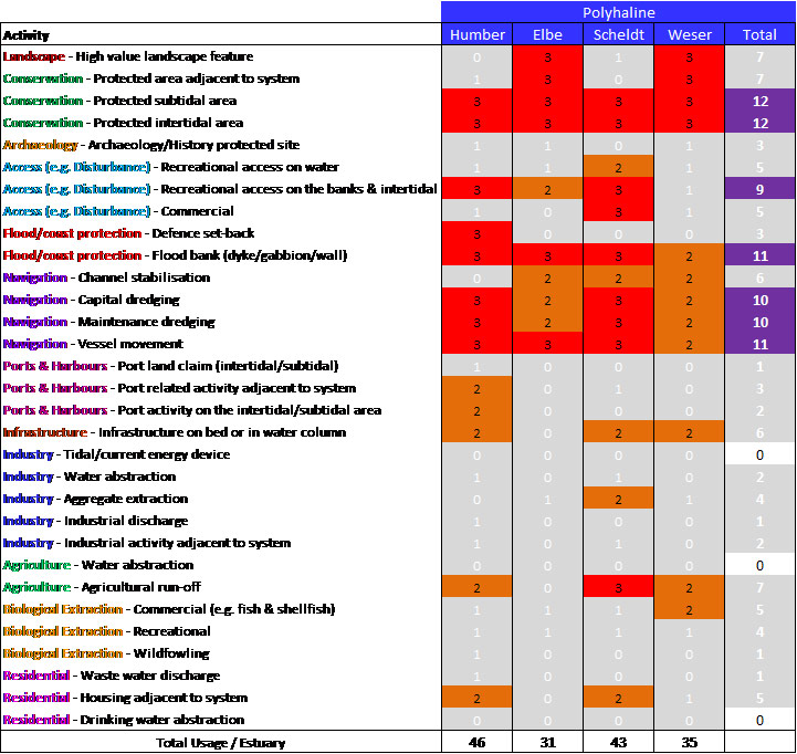
4c. Polyhaline Zone
Within the Humber, eight high level uses/issues scores were identified for the polyhaline zone, these being: protected areas for conservation in the subtidal; protected areas for conservation in the intertidal; recreational access along the banks and intertidal zone; flood defence set-back; flood protection from flood bank (dyke/gabion/wall); capital dredging; maintenance dredging for navigation;and vessel movement.For the Elbe, six high scoring uses/issues were identified: high value landscape; protected areas for conservation adjacent to the system; protected areas for conservation in the subtidal; protected areas for conservation in the intertidal; flood protection from flood bank (dyke/gabion/wall);and vessel movement.
On the Scheldt, nine high scoring uses/issues were noted, they being: protected areas for conservation in the subtidal; protected areas for conservation in the intertidal; recreational access along the banks and intertidal zone; commercial access; flood protection from flood bank (dyke/gabion/wall); capital dredging; maintenance dredging for navigation; vessel movement;and agricultural run-off.
The Weser group scored four of the uses/issues as high scoring in the polyhaline zone: high value landscape; protected areas for conservation adjacent to the system; protected areas for conservation in the subtidal;and protected areas for conservation in the intertidal.
Based on the above, the polyhaline zone featured eight high scoring uses/issues in the Humber, with a total score for the zone of 46, whilst for the Elbe, six high scoring uses/issues were identified, with a total score of 31. The Scheldt featured nine high scoring uses/issues giving a total score for the zone of 43, and the Weser featured 4 high scoring uses/issues with a total usage score of 35.
In the polyhaline zone, the categories of protected areas for conservation in the subtidal,and protected areas for conservation in the intertidal were afforded the highest score across all estuaries. By combining all estuary scores for the zone then the following uses/issues can be rated as a moderate/high combination (e.g. a score in excess of 8 from a maximum of 12), ranked from highest score downwards.
Polyhaline zone high uses/issues categories:
- Protected areas for conservation in the subtidal (12)
- Protected areas for conservation in the intertidal (12)
- Flood protection from flood bank (dyke/gabion/wall) (11)
- Vessel movement (11)
- Capital dredging (10)
- Maintenance dredging for navigation (10)
- Recreational access along the banks and intertidal zone (9)
Further details of the uses/issues analysis for the mesohaline zone are given below in Figure 9.
4c. ESTUARY ZONE SCORES COMPARISON
Figure 10 summarises the uses/issues scores for each estuary and zone, as well as for all estuaries combined.This indicates that for all of the TIDE estuaries combined, the zone with the greatest uses/issues is the mesohaline zone and with the polyhaline zone featuring the lowest uses/issues (at c. 80% of the level identified in the mesohaline).
Across all of the TIDE estuaries, the greatest level of uses/issues was identified for the Scheldt estuary, with the Elbe featuring the lowest score (c. 75% of the score for the Scheldt).
The Elbe and the Weser recorded the highest individual uses/issues scores in the limnetic zone, although for the Weser, the same score was also recorded from the mesohaline zone. The Scheldt recorded the highest uses/issues score in the oligohaline, with the Humber peak occurring from the mesohaline zone.

4c. CONCLUSIONS
Based on this uses/issues scores analysis undertaken by the RWGs for each estuary, it is concluded that for the four TIDE estuaries:- In terms of high level functional importance Ecological Function & Diversity was considered most important and Recreation & Social Use was considered the least important;
- The most frequently highly scored uses and users relate to conservation protection, navigation and flood protection attributes in most zones from all estuaries;
- The identified level of use is greatest in the Scheldt and lowest in the Elbe;
- The identified level of use across the estuaries is greatest in the mesohaline zone and lowest in the polyhaline zone;
- Relative proportion of salinity zones within each estuary varies, with the Humber being most atypical with a much reduced limnetic zone.
4b. Regional Working Group (RWG) Composition and Interests Comparison 4d. Generic Estuary Conflict Scores
Important to know
Reports / Measures / Tools
| Report: | Zonation of the TIDE estuaries (Functioning) |
|---|---|
| Report: | Ecosystem Service Assessment of TIDE Estuaries (Functioning) |
| Report: | Legislative Drivers & Sectoral Plan Review of TIDE Estuaries (Governance) |
Management issues
How can management actions be prioritised based on conflict assessment outcomes?How can multiple estuarine resource use be managed in an integrated way within the existing planning system?
How can the Ecosystem Services Approach be used to support management decisions?
How do TIDE estuaries deal with management problems?
How does the societal demand for ecosystem services vary along the estuary gradient?
What are the key areas of conflicts or synergies in TIDE estuaries?
What tool is available to help manage multiple users of a resource in an integrated way (i.e. achieving more holistic management)?
What tools are useful for involving local communities and stakeholders?
Which aspects do I have to take into account in order to make a measure a success?
Which synergistic effects and conflicts can be expected by planning and implementing a certain measure?