Project part-financed by the European Union (European Regional Development Fund)

The Interreg IVB North Sea Region Programme


Disclaimer:
The authors are solely responsible for the content of this report. Material included herein does not represent the opinion of the European Community, and the European Community is not responsible for any use that might be made of it.
Back to overview measures


Walsoorden pilot part B (2006): relocation of dredged sediment to a shallow water area at the edge of the Walsoorden sandbar

Monitoring

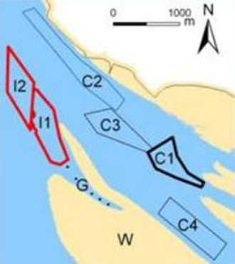
The extensive morphological and ecological monitoring program that was started at the beginning of the first relocation test (2004) was continued in time. The same criteria to evaluate the relocation test were incorporated from the first test, both morphologically (a new control area was defined to evaluate the stability of the relocated material) as ecologically. The topobathymetric surveys were continued using the multibeam echo sounder technique at a regular basis (weekly soundings in a smaller area around the relocation area and monthly soundings in a larger area around the relocation area). These surveys allowed volume computations for the control area. Additionally, the altitude of the Walsoorden sandbar was measured twice from an airplane (LIDAR technique). Sediment transport was also monitored with a measurement campaign (before, during and after the relocation test), as well as with a sediment tracing test after the relocation. The ecological monitoring program, with both subtidal and intertidal monitoring, of the first pilot study (2004) was continued considering both the first and the second relocation area as an impact zone (Figure 4: I1 and I2). A new control area was defined with similar hydrodynamic characteristics as the relocation areas (zone C1). Important aspects that were studied are related to the consistency of the soil (grain size and mud-percentage) and macrobenthos colonisation (biomass, diversity and density). To observe the developments of the Walsoorden sandbar as a whole, a flight was executed while using remote sensing and hyperspectral analysis. The goal of this extensive ecological monitoring program was to see whether the in situ relocation test caused a significant effect on all measured parameters, thus affecting the local ecology.


Back to top

Important to know

Reports / Measures / Tools

Report: Management measures analysis and comparison