
Disclaimer:
The authors are solely responsible for the content of this report. Material included herein does not represent the opinion of the European Community, and the European Community is not responsible for any use that might be made of it.
Back to overview measures
Historical data were analysed to identify volume changes (net volume change between two historical surveys). This can give an insight in short term and long term ‘net’ morphological evolutions.
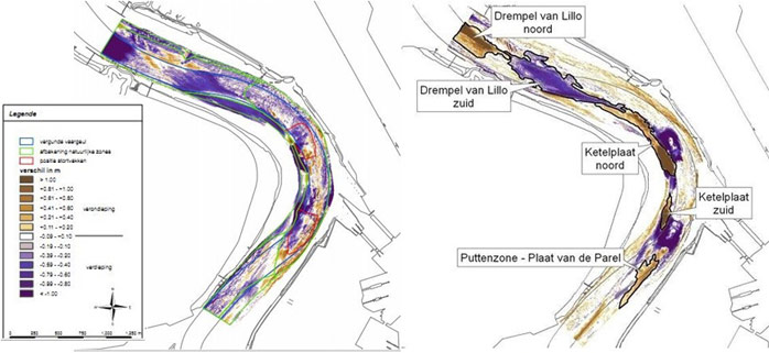
Data from the relocation test were analysed and reported to identify volume changes at the test sites before, during and after the test. ‘Depth maps’ and ‘difference maps’ were developed. Net volume changes were analysed between every two consecutive relocation test surveys, between the first and the last survey before the execution of the relocation test (short term natural evolution), between the last survey before and the first survey after the relocation test (evolution during the test), and between the first and the last survey after the test (evolution after the test). The difference maps were also developed in combination with the dredged volumes to show the location, the time and the volume of relocated dredged material. For both relocation sites longitudinal profiles were developed for the periods before, during and after the execution of the relocation test. Finally, the net volume change for the defined erosion and sedimentation areas after the relocation test were calculated to analyse if the disappeared material from the relocation sites could be found in the nearby areas (see Figure 3).
Back to top
TIDE pilot project 2: Navigation channel near Ketelplaat – Relocation of dredged sediment to deep areas of the navigation channel
Table of content
- 1. Description of measure
- 1a. Measure description
- 1b. Monitoring
- 1c. Monitoring results
- 2. Execution of main effectiveness criteria
- 2a. Effectiveness according to development targets of measure
- 2b. Impact on ecosystem services
- 2c. Degree of synergistic effects and conflicts according to uses
- 3. Additional evaluation criteria in view of EU environmental law
- 3a. Degree of synergistic effects and conflicts according to WFD aims
- 3b. Degree of synergistic effects and conflicts according to Natura 2000 aims
- 4. Crux of the matter
- 5. References
Additional information
for this measure:
No further information available.
for this measure:
No further information available.
Monitoring
The monitoring of this measure is completed. The monitoring was based on a wide range of data: week and day reports for dredging and relocation volumes, dredging statistics, data from the Dredging Information System, measures on the relocation areas and GIS shape files. Multibeam surveys were performed with increased frequency and extended area compared to regular surveys.Historical data were analysed to identify volume changes (net volume change between two historical surveys). This can give an insight in short term and long term ‘net’ morphological evolutions.
Data from the relocation test were analysed and reported to identify volume changes at the test sites before, during and after the test. ‘Depth maps’ and ‘difference maps’ were developed. Net volume changes were analysed between every two consecutive relocation test surveys, between the first and the last survey before the execution of the relocation test (short term natural evolution), between the last survey before and the first survey after the relocation test (evolution during the test), and between the first and the last survey after the test (evolution after the test). The difference maps were also developed in combination with the dredged volumes to show the location, the time and the volume of relocated dredged material. For both relocation sites longitudinal profiles were developed for the periods before, during and after the execution of the relocation test. Finally, the net volume change for the defined erosion and sedimentation areas after the relocation test were calculated to analyse if the disappeared material from the relocation sites could be found in the nearby areas (see Figure 3).
