

Disclaimer:
The authors are solely responsible for the content of this report. Material included herein does not represent the opinion of the European Community, and the European Community is not responsible for any use that might be made of it.
Back to overview measures
Whilst the primary aim of the site is flood defence, flooding of the site has led to the development of valuable intertidal habitat including mudflats, saltmarsh, lagoons and reedbeds which will provide compensation for habitat loss (due to port developments and land claim) elsewhere in the estuary. Due to the introduction of new European Directives (Natura 2000) and UK legislation there was a requirement to carry out the scheme in compliance with the requirements of the European Habitats Directives and the UK Habitats regulations 1994. A further objective of the scheme is to create new intertidal habitats to offset those lost through coastal squeeze within the estuary and due to flood defence works. The site was designed to create replacement habitat to compensate for both coastal squeeze (on a 1:1 ratio of habitat loss to creation for coastal squeeze), and for direct construction related losses from defence improvement works in the upper estuary (on a 1:3 ratio for habitat loss to creation for direct construction related losses).
Alkborough has a has a total area of 440 hectares, of which 370 hectares lie between the tidal defence and the 5mOD contour at the base of the escarpment. The remaining 80 hectares lie between the tidal defence and the low water mark. Prior to the opening of the scheme land levels within the site varied between 2mOD and 4mOD. The land at Alkborough has been reclaimed from the estuary over many years with the most recent phase of reclamation in the 1950s. The project was designed to reverse this trend and allow the land to be re-connected to the estuary.
One of the major restrictions to the managed retreat at Alkborough was the need to maintain navigability in the Humber Estuary, for which the engineering solution was to lower the outer defence with the Humber but to breach only an armoured 20-metre gap through which the tidal cycle moves water on and off the inundated part of the Alkborough site. The remaining 1,500 metres of embankment with the Humber was lowered to act as a weir and permit overtopping in extreme events; half was set at a level of 5.1m OD with the remainder set at 5.45m OD. Figure 6 shows the general layout of the site.
On the shoreline with the River Trent, which joins the Ouse on the outer corner of the Alkborough Flats site, the old flood bank was retained to prevent remeandering of the river, and also thereby to protect navigation in the Humber. A new setback bank has been constructed on the landwards side of the Alkborough site to protect a pre-existing sewage treatment works.
Now 170 hectares of the site is permanently exposed to flooding, reverting to mudflat, saltmarsh and, at least in part, reedbed. The remaining 230 hectares of land beyond the regularly inundated areas will serve as storage capacity during extreme surge events.
Status of the measure
The measure was breached in September 2006.
Back to top
Alkborough Managed Realignment
Table of content
- 1. Measure description
- 1a. Measure description
- 1b. Monitoring
- 1c. Monitoring results
- 2. Execution of main effectiveness criteria
- 2a. Effectiveness according to development targets of measure
- 2b. Impact on ecosystem services
- 2c. Degree of synergistic effects and conflicts according to uses
- 3. Additional evaluation criteria in view of EU environmental law
- 3a. Degree of synergistic effects and conflicts according to WFD aims
- 3b. Degree of synergistic effects according to Natura 2000 aims
- 4. Crux of the matter
- 5. Literature
Measure description
The measure ‘Alkborough managed realignment’ was the fourth major MR scheme on the Humber created by the Environment Agency. The Alkborough site, located in Lincolnshire at the confluence of the River Ouse and River Trent, is 440ha and is the largest managed realignment site on the Humber. The primary purpose of the site was to provide flood protection as the size of the site enables large capacity for water storage and reduces tidal levels throughout the upper estuary, thus delaying the need to raise other flood defences. The site’s capacity is so great that it could reduce high tide levels in the upper estuary by as much as 150mm.Whilst the primary aim of the site is flood defence, flooding of the site has led to the development of valuable intertidal habitat including mudflats, saltmarsh, lagoons and reedbeds which will provide compensation for habitat loss (due to port developments and land claim) elsewhere in the estuary. Due to the introduction of new European Directives (Natura 2000) and UK legislation there was a requirement to carry out the scheme in compliance with the requirements of the European Habitats Directives and the UK Habitats regulations 1994. A further objective of the scheme is to create new intertidal habitats to offset those lost through coastal squeeze within the estuary and due to flood defence works. The site was designed to create replacement habitat to compensate for both coastal squeeze (on a 1:1 ratio of habitat loss to creation for coastal squeeze), and for direct construction related losses from defence improvement works in the upper estuary (on a 1:3 ratio for habitat loss to creation for direct construction related losses).
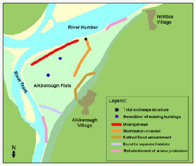
Alkborough has a has a total area of 440 hectares, of which 370 hectares lie between the tidal defence and the 5mOD contour at the base of the escarpment. The remaining 80 hectares lie between the tidal defence and the low water mark. Prior to the opening of the scheme land levels within the site varied between 2mOD and 4mOD. The land at Alkborough has been reclaimed from the estuary over many years with the most recent phase of reclamation in the 1950s. The project was designed to reverse this trend and allow the land to be re-connected to the estuary.
One of the major restrictions to the managed retreat at Alkborough was the need to maintain navigability in the Humber Estuary, for which the engineering solution was to lower the outer defence with the Humber but to breach only an armoured 20-metre gap through which the tidal cycle moves water on and off the inundated part of the Alkborough site. The remaining 1,500 metres of embankment with the Humber was lowered to act as a weir and permit overtopping in extreme events; half was set at a level of 5.1m OD with the remainder set at 5.45m OD. Figure 6 shows the general layout of the site.
On the shoreline with the River Trent, which joins the Ouse on the outer corner of the Alkborough Flats site, the old flood bank was retained to prevent remeandering of the river, and also thereby to protect navigation in the Humber. A new setback bank has been constructed on the landwards side of the Alkborough site to protect a pre-existing sewage treatment works.
Now 170 hectares of the site is permanently exposed to flooding, reverting to mudflat, saltmarsh and, at least in part, reedbed. The remaining 230 hectares of land beyond the regularly inundated areas will serve as storage capacity during extreme surge events.
Status of the measure
The measure was breached in September 2006.